The Modern Geology Field Guide: Paper, Digital, or Both?
A geology field guide is whatever you carry to answer two questions on the outcrop: what is this rock, and why is it here? For a century that meant a printed handbook of identification keys and property tables. Today it increasingly means a geology app that adds photo identification, GPS locality maps, offline access, and collection logging. This guide covers what classic paper field guides still do well, where they fall short in the field, what a digital field guide adds, and a practical five-step field workflow — plus the reference tables worth committing to memory either way.
What classic field guides teach
Printed field guides have earned their place in every pack pocket, and the good ones teach a way of thinking, not just names:
- Systematic identification keys. The best guides walk you through a decision tree — luster, then hardness, then streak, then cleavage — until you converge on a mineral. Learning to key out specimens builds real skill that no shortcut replaces. (Our mineral identification guide teaches the same method.)
- Property tables. Hardness, specific gravity, crystal habit, streak color, and diagnostic tests, all cross-referenced.
- Reference photos and plates. Ideally showing minerals as rough field specimens, not just museum showpieces.
- Locality and geology context. Regional guides explain which formations produce what, and where the classic collecting districts are.
None of that has stopped being valuable. A paper guide needs no battery, survives rain and drops (mostly), and forces you to observe carefully because it can't observe for you.
Where paper struggles in the field
Anyone who has actually keyed out a specimen on a windy talus slope knows the limits:
- Search is linear. You can't ask a book "translucent, waxy, scratches glass, found in basalt" — you flip pages and cross-reference tables while the light fades.
- One photo per mineral, if that. Real specimens vary wildly. A single studio photo of ideal fluorite doesn't look much like the weathered cube in your hand.
- No location awareness. A book can say "found in the Thomas Range"; it can't show you where you are relative to the locality, or whether you're on land where collecting is allowed.
- Frozen at press time. Localities close, new sites open, mineral classifications get revised. A 2005 printing is a 2005 snapshot.
- No memory of your finds. The book identifies; your notebook logs; your camera photographs; your GPS records the spot. Four tools, four places for data to get separated.
What a digital field guide adds
A well-built geology app is not a book on a screen — it's a different instrument. Here's what the digital format does that paper can't, using the Rockhound app as the concrete example:
- Photo identification. Point the camera at a specimen and get a candidate identification in seconds, with a confidence score that tells you how much weight to give it. Shoot multiple angles for tricky material.
- Instant, deep search. A database of thousands of minerals — Mohs hardness, crystal systems, chemical formulas, optical and mechanical properties, formation environments — searchable in the time it takes to open a book's index.
- GPS-tied localities. An atlas of 200,000+ documented collecting sites with BLM and Forest Service land overlays, so the "where" half of field geology lives on the same screen as the "what."
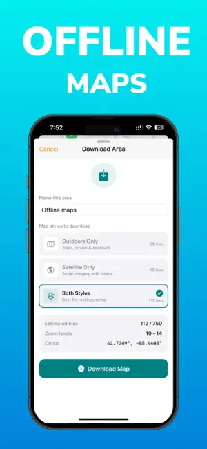
- Offline maps. Download outdoors and satellite tiles before the trip; the atlas keeps working where cell coverage doesn't. See our guide to finding collecting sites near you.
- Up-to-date data. Mineral records carry IMA status, and app data updates rather than aging on a shelf.
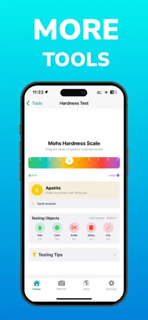
- A built-in Mohs tool. An interactive hardness tester keyed to common objects — fingernail (2.5), coin (3.5), knife (5.5), glass (5.5), file (6.5) — so the scratch-test logic travels with you.
- Collection logging with locations. Every identified specimen can be saved with photos, notes, and the GPS spot where you found it, organized into custom collections with cloud backup. The identify–photograph–log loop happens in one place.
- Human backup. Uniquely, Rockhound lets you send an uncertain identification to a professional geologist and get confirmation or correction within 24–48 hours.

Rockhound: Rock Identifier — a complete digital field guide: photo ID with confidence scores, a full mineral database, Mohs tool, and offline locality maps. Free on iOS.
Download FreeThe verdict: carry both
This isn't really a competition. A compact paper guide weighs a few ounces, teaches method, and works when your phone dies. A digital field guide does the searching, mapping, and logging that paper never could. The strongest field kit is a regional paper guide in the pack lid and a geology app on your phone — with offline maps downloaded and a battery bank in the side pocket.
The field workflow: observe → test → photograph → identify → log
Tools matter less than process. Here's the workflow that turns a walk into fieldwork, whether you're a rockhound or a student on your first mapping exercise:
- Observe. Before touching a tool, describe the specimen to yourself: color on fresh and weathered surfaces, luster, grain size, visible crystals or banding, how it sits in the outcrop. Context is data — a mineral in basalt suggests different candidates than the same color in a granite pegmatite.
- Test. Run the cheap, decisive field tests. Hardness first (see the anchors below), then streak if you carry a porcelain tile, then heft — density you can feel — and cleavage versus fracture on a broken edge. Two minutes of testing eliminates most wrong answers. Our guide to identifying minerals covers each test in detail.
- Photograph. Shoot the specimen in diffuse light against a neutral background: one overall shot, one close-up of the freshest surface, one with something for scale. Multiple angles help both the AI and any human expert you consult later.
- Identify. Combine your observations with the tools: run the photo ID, check the confidence score, and read the database entry to see whether hardness, habit, and environment actually match what you observed. If the pieces don't agree, stay skeptical — or send it for geologist review.
- Log. Save the find with its photos, your test notes, and the GPS location, in the field, before you move on. Specimens logged "later, at home" have a way of becoming specimens from "somewhere in Nevada."
For students and educators
A digital field guide earns its place in coursework, not just hobby collecting. Rockhound's mineral database carries the properties mineralogy classes actually drill:
- Crystal systems and morphology — cubic, tetragonal, hexagonal, trigonal, orthorhombic, monoclinic, triclinic — for every database mineral.
- Chemical formulas and elements, so students connect a hand sample to its composition (quartz SiO₂, calcite CaCO₃, pyrite FeS₂).
- Optical and mechanical properties and formation environments, linking hand-specimen work to petrology.
- IMA status — whether a species is approved by the International Mineralogical Association — which teaches students the difference between mineral species and informal or varietal names.
For instructors, the photo-ID-plus-confidence-score pattern is itself a teaching moment: students propose an identification from observed properties, then compare against the AI's ranked answer and discuss the disagreements. And because it's an iPhone app, every student already carries the lab reference on the field trip.
Reference tables worth memorizing
No field guide, paper or digital, replaces a few memorized anchors. These two tables cover most day-one identification work.
Mohs hardness anchors
| Tester | Approx. hardness | What it tells you |
|---|---|---|
| Fingernail | 2.5 | Scratches gypsum (2) and talc (1); can't scratch calcite (3). |
| Copper coin | 3.5 | Scratches calcite; can't scratch fluorite (4). |
| Steel knife / window glass | 5.5 | The big divider: scratches apatite (5) and softer; feldspar (6) and quartz (7) scratch the glass instead. |
| Hardened steel file | 6.5 | Scratches feldspar; quartz (7) and harder resist it. |
The full ten-step scale, from talc (1) to diamond (10), is covered in our Mohs hardness scale guide — and lives in the app as an interactive tool.
Common rock-forming minerals
| Mineral | Mohs | Quick field signature |
|---|---|---|
| Quartz | 7 | Glassy, no cleavage (conchoidal fracture), scratches glass easily. |
| Feldspar (orthoclase, plagioclase) | 6–6.5 | Blocky with two cleavages near 90°; pink, white, or gray; the most abundant mineral group in the crust. |
| Muscovite / biotite mica | 2–3 | Peels into flexible, shiny sheets — one perfect cleavage. |
| Calcite | 3 | Rhombic cleavage, scratched by a coin, fizzes in dilute acid. |
| Amphibole (hornblende) | 5–6 | Dark prisms, two cleavages at ~56°/124°. |
| Pyroxene (augite) | 5.5–6 | Dark, stubby crystals, cleavages near 90°. |
| Olivine | 6.5–7 | Glassy olive-green grains, common in basalt. |
| Pyrite | 6–6.5 | Brassy metallic cubes, greenish-black streak — the classic "fool's gold." |
Learn these eight and you can name most of what makes up common igneous and metamorphic rocks — everything else is looking up the exceptions.
Frequently asked questions
What is a geology field guide?
A geology field guide is a reference you carry into the field to identify rocks and minerals and understand local geology. Classic examples are printed handbooks with identification keys, photos, and property tables. Today the term also covers geology apps that add photo identification, GPS locality maps, offline access, and collection logging.
Is a geology app better than a paper field guide?
They solve different problems. Paper guides teach systematic identification and never run out of battery, but they can't search by photo, show your position on a locality map, or log finds with GPS. Most field geologists and serious rockhounds carry both: a compact paper reference and a digital field guide app like Rockhound.
What should a digital geology field guide include?
Look for photo-based identification with confidence scores, a searchable mineral database with Mohs hardness, crystal systems, and chemical formulas, GPS-tied locality maps that work offline, a hardness testing tool, and collection logging that records photos, notes, and locations for every specimen.
What Mohs hardness anchors should I memorize?
Memorize the everyday testers: fingernail about 2.5, copper coin about 3.5, steel knife and window glass about 5.5, and a hardened steel file about 6.5. With those four anchors you can bracket almost any unknown mineral's hardness in the field in under a minute.
Is the Rockhound app useful for geology students?
Yes. Rockhound includes a mineral database with crystal systems, chemical formulas, optical and mechanical properties, formation environments, and IMA status — the same properties taught in mineralogy coursework — plus an interactive Mohs hardness tool and photo identification with confidence scores for lab and field practice.