Rockhounding Near Me: How to Find Rock Collecting Sites
Searching for "rockhounding near me" gets you listicles; what you actually need is a method. The honest answer is that where you can collect depends on who owns the land: most legal rockhounding in the United States happens on BLM land, in National Forests, at fee-dig mines, and on private land with the owner's permission. This guide explains each land type and its rules, tours the country's famous collecting regions, and shows how a locality map of 200,000+ sites turns "where do I even go?" into a Saturday plan.
The honest answer: it's a land-ownership question
There is no single map labeled "places you may collect rocks." The United States is a patchwork of federal, state, tribal, and private land, and every parcel carries its own rules. Two washes a hundred yards apart can be legally night-and-day: one open BLM land, the other a staked mining claim.
So finding rock collecting sites near you is really a two-step process:
- Find where interesting material occurs — documented mineral localities, gravel bars, road cuts, old mine districts.
- Check who owns that ground and what they allow — because geology doesn't respect property lines, but you have to.
Get both right and the country opens up. Here's how each land type works.
Land types, explained
BLM land: the rockhound's best friend
The Bureau of Land Management administers roughly 245 million acres, mostly in the West. Under the BLM's casual-use rules, hobby collection of reasonable amounts of common rocks, minerals, and gemstones for personal use is generally allowed without any permit. The key limits:
- Reasonable amounts — think bucket, not truckload. Petrified wood has specific daily and annual limits.
- Personal use only — no collecting for sale or barter. Commercial collection requires a contract or permit.
- Hand tools only — no explosives, no heavy machinery, no significant surface disturbance.
- Respect claims and closures — active mining claims, wilderness study areas, and special management areas may be off-limits.
Rules can vary by field office, so verify locally when in doubt. But if you live in the West, open BLM land is very likely your nearest legal collecting ground.
National Forests: generally yes, with local variations
The Forest Service generally permits small-scale, personal collection of common rocks and minerals on National Forest land. Individual forests and ranger districts can impose their own restrictions — some famous localities inside forests have special rules or seasonal closures — so a quick call or website check for the specific district is worth the five minutes.
State land: a fifty-state patchwork
State trust lands, state forests, and state parks each set their own policies, and they range from permissive to zero-tolerance. Some states allow casual collecting on certain state lands with a permit; many state parks prohibit removal of anything. Never assume state land works like BLM land — look up your state's rules.
National parks and monuments: never
Removing rocks, minerals, or fossils from a national park or national monument is a federal offense, full stop. Enjoy the geology with your camera.
Private land: ask, and you'll be surprised
Farmers and ranchers sit on some of the best undisturbed collecting ground in the country. Knock, introduce yourself, explain what you're looking for, and offer to share your finds. Plenty of long-running club sites started with exactly that conversation. Get permission every visit, close every gate, and fill every hole — access is renewed by behavior.
Fee-dig sites: pay to play, and worth it
Fee-dig mines charge admission — usually $10–$50 per person — and let you keep what you find. For beginners and families they're unbeatable:
- Legality is guaranteed. No claim research, no permission letters.
- Material is abundant. You're digging where the good stuff is known to be, often in refreshed or salted-free productive ground.
- Help is on hand. Staff will tell you what you found and how to clean it.
Famous examples include the quartz mines around Mount Ida, Arkansas, sunstone pits in Oregon, and gem mines across the Carolinas and Virginia. If you're just starting out — perhaps after reading our rockhounding for beginners guide — make your first trip a fee dig.
Famous US rockhounding regions
Wherever you live, one of these regions is probably within a tank of gas. What follows is a broad-strokes tour — every one of these areas contains hundreds of documented localities.
Oregon and Washington: agates and thundereggs
The Pacific Northwest may be the best beginner rockhounding territory in America. Oregon's beaches and rivers produce agates and jaspers by the bucket; central Oregon is world-famous for thundereggs (agate-filled nodules, Oregon's state rock) and sunstones; Washington adds petrified wood, carnelian, and more coastal agates. Much of the region is BLM and National Forest land.
California: variety on a grand scale
From tourmaline district country in San Diego County to jade coves on the Big Sur coast, desert agate and jasper fields in the Mojave, and benitoite — the state gem, found essentially nowhere else on Earth. Land status is a patchwork, so map research matters here more than most places.
Arizona and New Mexico: copper country and petrified wood
Arizona means azurite, malachite, and turquoise from its copper districts, plus fire agate and amethyst. Petrified wood is abundant — just remember the Petrified Forest National Park itself is strictly off-limits; collect on surrounding private and BLM ground. New Mexico adds Rockhound State Park (one of the rare parks that lets you take material home), fluorite, and smithsonite country.
Utah: topaz and trilobites
Topaz Mountain in the Thomas Range produces Utah's state gem — sherry-colored topaz crystals you can chip from rhyolite cavities on open ground. The western deserts add red beryl country, obsidian fields, and some of the world's most productive trilobite quarries, including family-friendly fee digs.
Arkansas: quartz capital, plus real diamonds
The Ouachita Mountains around Mount Ida and Hot Springs are the quartz crystal capital of North America, with numerous fee-dig mines where clear points practically fall out of the clay. And Crater of Diamonds State Park near Murfreesboro is the only place in the world where the public can dig genuine diamonds and keep them — visitors find hundreds every year.
The Great Lakes: agates on the beach
Lake Superior agates — banded in iron-oxide reds and oranges — wash up on beaches and fill gravel pits across Minnesota, Wisconsin, and Michigan's Upper Peninsula. Michigan adds Petoskey stones (fossil coral, the state stone) on Lake Michigan beaches and datolite and native copper in the Keweenaw. Beach combing is about as low-barrier as rockhounding gets; just check local beach rules.
The Appalachians: gems of the East
Western North Carolina's mountains hide emeralds, aquamarine, garnets, and a dense cluster of fee-dig gem mines around Franklin and Spruce Pine. Virginia offers amazonite and fee-dig amethyst; Maine's pegmatites produce tourmaline; Pennsylvania and New Jersey have their famous mineral dumps; Herkimer, New York, gives the world its double-terminated "Herkimer diamond" quartz at several pay-to-dig mines.
How the Rockhound atlas solves "where do I go?"
Everything above is knowable, but pulling it together — localities from old guidebooks, land ownership from county maps, claim status from federal records — used to take evenings of research per trip. This is the exact problem the Rockhound app was built to solve:
- 200,000+ mapped localities. Known mineral collecting sites across the country, with site details and directions.
- BLM and Forest Service overlays. See at a glance whether a locality sits on land where casual collecting is generally allowed — the land-ownership question, answered on the same screen.
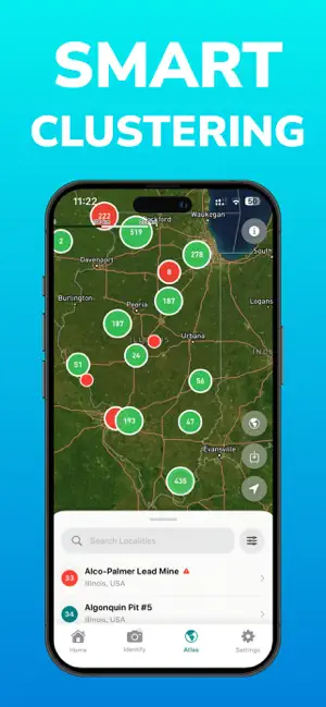
- Smart clustering. Dense districts collapse into readable clusters that expand as you zoom, so 200,000 pins never become soup.
- Offline maps. Download outdoors or satellite tiles before you leave pavement. The best collecting is usually beyond cell coverage.
- Hidden Gems. Curated locations with photos, videos, and collecting tips — like having a club member riding shotgun.
- My Locations. Save your own spots into custom lists as you scout them.
The app doesn't replace your judgment — you still verify current rules and respect claims — but it collapses the research from hours to minutes.

Rockhound: Rock Identifier — open the atlas, see 200,000+ collecting sites near you with BLM and Forest Service lands marked, and download offline maps for the trip. Free on iOS.
Download Free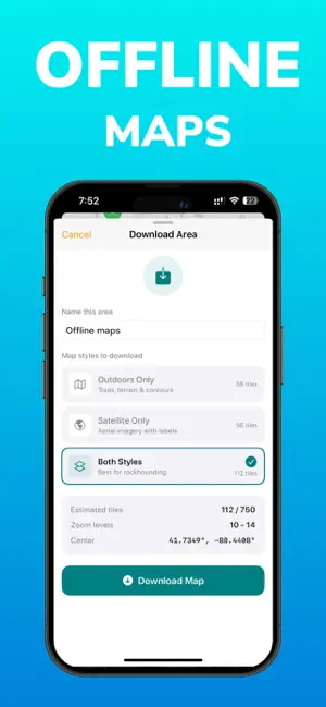
Trip-planning checklist
Before any collecting trip, run through this list. It takes ten minutes and prevents nearly every bad day in the field:
- Pick the site — from the atlas, a club trip, or a fee-dig listing — and read whatever details exist about what's found there and how.
- Confirm land status. BLM, Forest Service, state, or private? Any active claims or closures? When in doubt, call the local field office or ranger district.
- Check access and weather. Many sites need high clearance; desert washes flood; mountain roads close. Satellite view is your friend.
- Download offline maps for the area, and tell someone where you're going and when you'll be back.
- Pack for the site: water (more than you think), sun protection, first-aid kit, safety glasses, gloves, hammer and chisel, bucket and bags, and a wrapped box for delicate finds.
- Know your target. Skim what the material looks like rough — an uncut sunstone doesn't sparkle at you. Our guide on how to identify rocks covers the field basics.
- Log as you go. Photograph finds where they lie and save the GPS location — a specimen with a locality is worth ten without.
- Leave it better: fill holes, pack out trash, close gates. Access for the next rockhound depends on you.
Frequently asked questions
How do I find rockhounding sites near me?
Start with land ownership: most legal collecting happens on BLM land, in National Forests, at fee-dig mines, and on private land with permission. Use a locality map — the Rockhound app plots more than 200,000 collecting sites with BLM and Forest Service lands marked — then verify the current rules for the specific site before you go.
Can I collect rocks on BLM land?
Generally yes. Most BLM land allows casual, hobby collection of reasonable amounts of common rocks and minerals for personal use without a permit. You cannot collect for sale, use explosives or heavy equipment, or collect on someone's active mining claim. Some BLM areas have special closures, so check the local field office rules.
Is rockhounding allowed in national parks?
No. Collecting rocks, minerals, or fossils in national parks and national monuments is prohibited by federal law. The exception that proves the rule is Crater of Diamonds State Park in Arkansas — a state park specifically set up so visitors can dig and keep real diamonds.
What is a fee-dig site?
A fee-dig site is a privately owned mine or claim that charges admission — typically $10 to $50 per person — and lets you keep what you find. Access is guaranteed and legal, material is abundant, and staff help identify finds, which makes fee digs the single best option for beginners and families.
What are the best rockhounding states in the US?
Oregon and Washington are famous for agates and thundereggs, Arkansas for quartz crystal, Utah for topaz, Arizona and New Mexico for copper minerals and petrified wood, California for tourmaline and jade, and the Great Lakes shorelines for Lake Superior agates. Nearly every state has productive localities — the key is knowing where the public land is.
Does the Rockhound app show collecting sites near me?
Yes. Rockhound maps more than 200,000 collecting localities with BLM and Forest Service land overlays, site details, and directions. Smart clustering keeps dense regions readable, offline maps keep the atlas working without cell coverage, and Hidden Gems adds curated locations with photos, videos, and collecting tips.